FRIENDS OF CLAINES CHuRCH
Unlike many parishes Claines was never a single village.
It was a parish which was made up of eleven Hamlets.
These were;
- Beverburn (Barbourne)
- Hollow (Holy Claines)
- Eastwood (Astwood)
- Tapenhall
- Beverye (Bevere)
- Northwick
- Whiston (the Tything)
- Tollerdine
- Millnham (Mildenham)
- Hayford (Hawford)
- Smite
You will appreciate that many of these areas are now outside our parish of today.
Some of these Hamlets were very important;
- Northwick; A manor owned by the Bishops of Worcester dating from 680
- Mildenham; A mill on the River Salwarpe given by St Wulfstan to the Prior of Worcester in 1089
- Whiston; A nunnery of St Mary Magdelene founded in 1255 and St Oswalds Hospital
- Hawford; the “higher ford” crossing across the River Severn
- Bevere; A manor given to the Dean and Chapter of the Cathedral in 1542.
WHAT IS CLAINES?
Notes on the development of the Parish
Claines is a church (ecclesiastical ) parish, it is not, and never has been, a village.
It has changed its shape and boundaries over the years, mainly due to the population growth of the City of Worcester.
It is part of the civil parish of North Claines, which took over the responsibility for social welfare and civic duties from the ecclesiastical parish in 1894.
The boundaries of the church parish and the civic parish are very different and should not be confused!

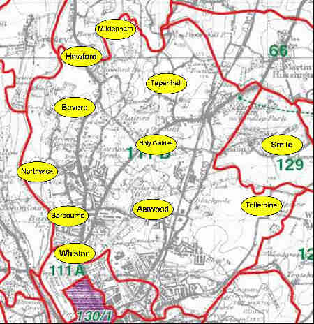
Claines Parish Boundary in 1850
Originally Claines was a chapelry of the main City Parish (St Helens). Its first church was called Northwick Chapel in 1097. Claines then became a separate parish in 1218.
It parish boundaries remained more or less the same until the 1800’s when the following changes were made:
- In 1880, under the Divided Parishes Act, Smite Hill was annexed to Hindlip.
- The tithing of Whistones was taken into the city of Worcester under the Municipal Corporation Act, 1832
- In 1885 Claines was divided into North Claines and South Claines, the latter being added to the city under the Worcester Extension Act.
As the population of Worcester City grew then new daughter parishes were created from Claines and it then became a geographically smaller parish. These were:
- St. Georges Barbourne, originally a chapelry of Claines until it became a separate parish in 1862.
- St Stephens; a daughter parish of Claines created in 1862.
- St Barnabas (with Christ Church), a daughter parish of Claines created in 1883
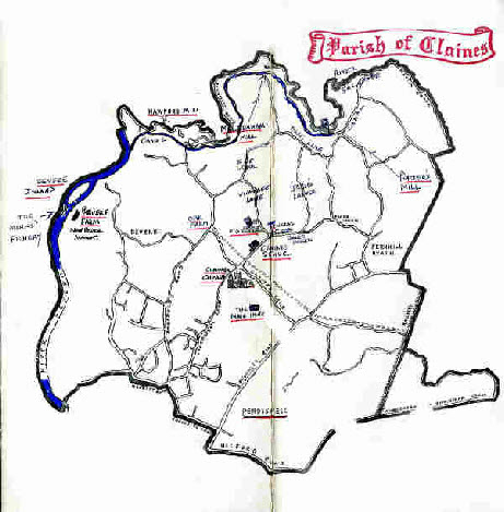
Claines Parish Boundary today
(Google)

Hawford

Mildenham
Tapenhall
Bevere

Holy Claines
Smite
Northwick
Barbourne
Astwood
Whiston
Tollerdine
Claines Parish Boundary in 1850, showing the locations of the original Hamlets in the parish pre 1800’s.
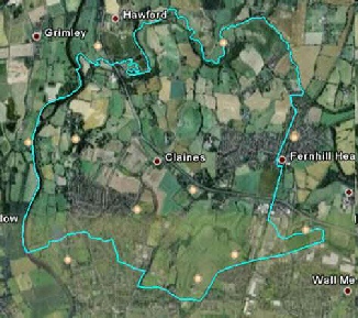
With thanks to Google Earth you can look at Claines Parish today from the air and zoom in to see whether you live there or not!
Make sure you are connected to the Internet and then follow the link below. Then view either as a map or an aerial photograph. (If you wish to view via Google Earth you may be prompted to install it if you have not done so already)
View the Parish via Google Earth
Many thanks to John Sansome who painstakingly digitised the boundary!
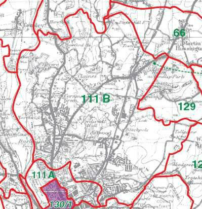
This is a sketch map from 1964 which shows the current parish boundary. (The exact Eastern boundary is uncertain and does not follow Station Road, but older field lines now lost, so most houses in the upper part of Station Road are not in the parish)